Climate III – Visualizing Our Big Picture
My blog about the drivers for our local climate noted that the Rockies and the Appalachians play an important role in shuttling air masses through the Midwest south from the Arctic and north from the Gulf. And the follow-up blog noted that the driver for our Polar Vortex in winter can be an overheated north Pacific.
All of this is easier to visualize if we look at real data from a real event. The satellite data for January 06, 2014, below, captured a perfect Polar Vortex on a day when our Prevailing Westerlies were modest and uniform, and did not distort it.
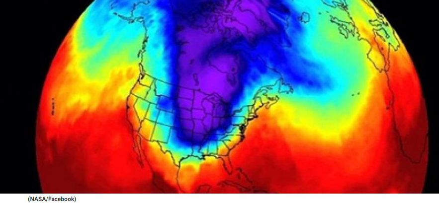
Open your atlas and locate the Rocky Mountains and the Appalachians, and compare to the position of the purple edges of the vortex on the temperature map above. You will note that the purple is bounded very nicely by the mountains on either side.
Note the bubble of not very cold north Pacific air pushing into most of Alaska, which is as mild on this day as most of Texas.
Note how New York City is on the edge of some quite warm (and wet) Atlantic air, and when that cold purple air pushes in a day or so later and chills it, there will be real winds and snow, a “northeaster.”
Meanwhile, there is no source of moisture handy for us and it will just be cold. The winds blow hard when the purple first pushes in, shoving the warmer air aside. But in the core of the vortex it is calm.
The southeast edge of the purple will stall a bit trying to get over Appalachians, but the whole purple vortex will continue to move inexorably eastward, driven by the Prevailing Westerlies, causing the southeast sector to partially spill further southeastward into flatland north Florida a day later, displacing the red and yellow with pale blue. Jacksonville will again have a freeze warning, which means at least several hours of 32 degrees Fahrenheit or slightly colder.
So it is not hard to foresee that if the north Pacific heats up a lot more and pushes deeper into Alaska, that the cold Arctic bubble might get squeezed more in our direction. We, out here in the chute between the Gulf and the Arctic, could get still colder events in winter as global warming increases and the atmospheric heat engine works harder.
Tags: climate change, Lon Drake